|
CHAPTER III: An Introduction to Afghanistan
SECTION I: LOCATION AND DESCRIPTION
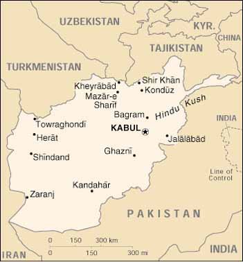
Lying more than 482 kilometers (300 miles) from the sea, Afghanistan is a
barren, mostly mountainous country of about 647,500 square kilometers (250,000
square miles). It is bordered by Turkmenistan, Uzbekistan, and Tajikistan to the
north, Pakistan to the east and south, and Iran to the west. Including a long,
narrow panhandle (the Wakhan Corridor) in the northeast, Afghanistan has a
northeast-southwest extent of about 11,450 kilometers (900 miles), and a
northwest-southeast extent of about 804 kilometers (500 miles). With peaks up to
about 7315 meters (24,000 feet), the Hindu Kush forms the spine of the country,
trending southwestward from the Pamir Knot to the central Afghan province of
Bamian. Subsidiary ranges continue to the south and the west with decreasing
elevations, gradually merging into the plains that continue into Iran and
Pakistan. A broad plateau stretches from north of the Hindu Kush to the Amu
Darya River and eventually to the Russian steppes. In the east, the mountains
are indistinguishable from those of Pakistan. Afghanistan is approximately the
size of Texas.
SECTION II: TOPOGRAPHY
About one-third of Afghanistan, in the southwest and north, is arid plain.
The southwestern plain is the larger of the two and is a barren desert with
large areas of drifting sand, scattered hill belts, and a few low mountains.
Small villages along a few intermittent streams, small settlements, and a narrow
band of cultivation along the Helmand River are the only features that break
desolation. The Helmand is one of the few perennial streams in the region. The
northern plains are actually steppes with seasonal grasslands supporting a small
nomadic population. Permanent settlements are located along the margin of the
steppes and on the flood plain of the Amu Darya River.
The mountains that comprise the other two-thirds of the country are the
perennially snow-capped Hindu Kush in the northeast and progressively lower
mountains in the west. The Hindu Kush have sharp-crested ridges and towering
peaks, while the lower, western mountains are generally rounded or flat-topped.
Afghanistan can be broken down into three military operational zones: the
Northern Steppe, the Afghan Highlands, and the Southwestern Desert Basins.
SECTION III: DRAINAGE
Afghanistan has four major river systems that originate in the Hindu Kush:
the Kabul, the Helmand, the Amu Darya, and the Harirud. Of the four, only the
eastward flowing Kabul ever reaches the ocean; the other three eventually
disappear into salt marshes or desert wastes. Only the Amu Darya (also known as
the Oxus) has significant navigable reaches. The rest are fordable for the
greater part of the year throughout their courses. The Amu Darya also serves as
the northern border of Afghanistan. The Helmand is the largest in flow and
volume and runs southward into across the southern desert into the salt marsh
wastes found along the Afghan-Iranian border. The Harirud runs westward past
Herat then turns northward, forming the border between Afghanistan and Iran.
All the Afghan rivers and their tributaries are used for irrigation.
Supplementing the stream irrigation is the karez, a system of underground
channels (with vertical access and maintenance shafts) carrying water from the
base of the mountain slopes to oases on valley floors. The signature of karez
(qanat in Iran), particularly noticeable from the air, is the row of evenly
spaced openings (shafts) surrounded by mounds of earth that define the course of
the underground channels.
SECTION IV: VEGETATION
What little natural vegetation there is in Afghanistan consists mainly of
bunch grasses; trees are scarce and mostly limited to planted poplars and
willows around settlements. Because of infertile soils and centuries of seeking
fuel and forage, even scrub and brush are difficult to find. Timber is mostly
absent. Any timber laying around the ground or attached to buildings in deserted
villages should be suspect for booby traps. Timber is very scarce and villagers
will booby trap their homes to prevent theft and pilferage.
Irrigated areas produce wheat, barley, corn, and rice, as well as sugar
beets, melons, grapes, cotton almonds, and deciduous fruits. The two primary
Afghan cash crops are opium poppy and cannabis. Afghanistan is the major opium
supplier for the European heroin market.
SECTION V: CLIMATE
Marked seasonal extremes of temperature and scarcity of precipitation
characterize Afghanistan’s climate. Topographic features strongly influence all
elements of the climate. Winters (December through February) are dominated by
constantly changing air masses associated with passing migratory lows and
frontal systems. Winters are cold, with nighttime temperatures below freezing
common in low elevations and frequent winter snows at higher elevations. To the
south and southeast the low-level temperatures are less severe. Winter snows are
frequent at the higher elevations and there are permanent snowfields in the
Hindu Kush. Summers (June through August) are continuously sunny, dry, and
severely hot; however, intrusions of moist, southerly monsoon air occasionally
bring rain, increased humidity, and cloudiness to the extreme eastern portions.
At elevations below 1,220 meters (about 4,000 feet) temperatures rise to over
38oC (100oF) on a daily basis. Very low humidity is normal
during the summer. In the other seasons, relative humidity is high in the early
morning and moderate in the afternoon over most sections. In most of
Afghanistan, winter and spring are the cloudiest periods, and clear skies are
common in summer.
Precipitation is scarce, with desert conditions prevailing in the
southwestern and northern plains. What annual precipitation there is falls
mostly in the winter and spring; summers are almost uniformly rainless.
Thunderstorms are most frequent during the spring, but also occur during summer
in extreme eastern portions of the country. Flash floods sometimes result from
severe thundershowers. Long droughts are not uncommon.
SECTION VI: THE ECONOMY
Afghanistan is one of the world’s poorest and least developed countries. The
geographical location of Afghanistan contributes to many of its features:
abundance of natural resources such as natural gas, petroleum, coal, copper, and
precious and semiprecious stones; varied but landlocked topography with mostly
rugged mountains, especially in the northeast, and plains in the north and
southwest; earthquakes and flooding; ethnic diversity; and a variety of
languages.
The Taliban, preoccupied by its determination to defeat the Northern
Alliance, did little to rebuild Afghanistan, which has been in economic disarray
since the end of Soviet occupation in 1989. Two decades of war and grinding
poverty have left Afghanistan in disrepair: Warfare has destroyed roads,
bridges, and canals, while looting and shortages of spare parts has shut down
power plants, factories, and telephone systems. Afghanistan has some of the
worst social indicators in the world: the highest rates of illiteracy; mother,
child, and infant mortality; malnutrition; and ratio of widows and orphans in
the population. These combine to produce one of the lowest life expectancies on
the globe. The bleak situation has prompted foreign aid efforts, such as the UN
World Food Program, which provides assistance during periods of drought.
SECTION VII: POPULATION FIGURES AND DISTRIBUTIONAfghanistan’s
population, estimated at 26,813,057 (U.S. Census Bureau, 2001) is characterized
by high growth, low quality of life, and an unusual settlement pattern brought
on by conflict and drought. The country is extremely young, with 42 percent of
the population under the age of 15. Life expectancy is under 40 years,
reflecting the overwhelmingly poor living conditions throughout the country. The
majority of the people (about 60 percent) live in rural areas, about 30 percent
live in cities, and 10 percent live a nomadic lifestyle. These percentages are
rough estimates, however, because the ongoing civil war and a succession of poor
growing seasons have forced over 3 million Afghanis to become refugees. Between
600,000 and 800,000 people were internally displaced as of the end of 2000,
according to the UN Office for the Coordination of Humanitarian Affairs. The UN
High Commissioner for Refugees estimates that 2.5 million Afghanis have migrated
out of the country.
SECTION VIII: ETHNICITY AND LANGUAGE
Afghanistan is a complex mosaic of ethnolinguistic groups. The dominant
group, politically and in terms of numbers, has been the Pashtun, who consider
themselves the “true” Afghani people. Pashtuns are Sunni Moslems, tribally
organized, speak Pashtun, and comprise between 35 and 50 percent of the
population. The Pashtun live primarily in the south and east areas of
Afghanistan, which include the cities of Kandahar and Kabul, respectively.
Throughout Afghanistan’s history, tribal rivalries have characterized the
Pashtun people, but tribes have tended to put aside such differences when faced
by a common enemy, such as the British in the 19th century and the Soviets in
1979.
The Tajiks are the principal ethnic group of Afghanistan’s northeast. Tajiks
comprise about 25 to 30 percent of the population and are defined as Sunni
Moslems who speak Dari, a derivative of Farsi. Animosity between the Tajiks and
Pashtuns has been a hallmark of internal politics since the British were driven
out in the 19th century.
The Hazaras, who make up about 15 percent of the population, are concentrated
primarily in the center of the country. Hazaras are characterized by Mongoloid
features and practice the Shia variety of Islam. Historically, the lowest group
on the Afghan social ladder, the Hazaras have endured discrimination and poor
living conditions for centuries. Most are engaged in agricultural activities.
The final large ethnic group in Afghanistan are the Uzbeks, whose numbers
have diminished in recent years as many have migrated to Uzbekistan. Located
primarily in the north-central section of the country, the Uzbeks speak Uzbeki
and comprise about 10 percent of the national population.
SECTION IX: RELIGION
As of 1979, 99.7 percent of the Afghan population was of the Moslem faith,
and the remainder was largely Hindu. In Taliban-held areas, Islam was the
dominant force in everyday life, imposing a draconian form of sharia law. Under
this legal system, all tenets of the Muslim faith were adhered to, or a
punishment was meted out. Religious police carried small whips, which they used
to publicly flog people if some aspect of their appearance or behavior was not
in compliance with Muslim law. Hangings took place on a regular basis. Women
were not allowed to receive an education and only worked outside the home if
they were involved in health services. Conversion to another faith could be
punishable by death. There was an initiative on the part of the ruling Taliban
to make Hindus wear identity badges – ostensibly to protect them from the
religious police.
SECTION X: KEY CITIES
Kandahar. Kandahar is located is southern Afghanistan, approximately
500 kilometers (310 miles) southwest of Kabul and 90 kilometers (56 miles)
northwest of the Pakistan border. The city lies at the northeast corner of the
vast, nearly uninhabited Dasht-i Margow. Kandahar is in an area of subtropical
steppe. Sand ridges and dunes alternate with expansive desert plains. There are
also areas of barren gravel and clay where sparse vegetation and low growth
prevail. Kandahar’s population is estimated at 329,300 (U.S. Census Bureau,
2001).
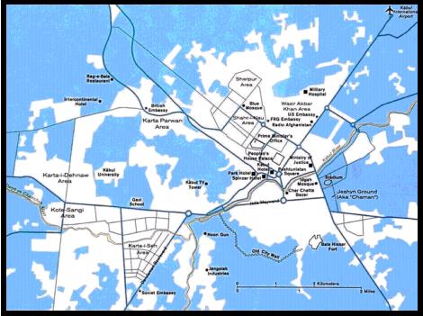
Kabul. Kabul is located in northeastern Afghanistan on the banks of
the Kabul River. The city spreads out on the north and south banks of the river
and is further separated into northern and southern sections by a series of low
hills. The Kabul River flows from southwest to northeast and through the water
gap known as “Lion’s Gate,” which divides the hills. Elevations range from 1,789
meters above sea level at Kabul International Airfield to 2,219 meters at Kohe
Sher Peak near the city center. Several small streams flow in from the west,
joining to form the Cheltan River, which, in turn, joins the Kabul River just
south of the Lion’s Gate. The Logar River flows north to join the Kabul River in
eastern Kabul; Khargz Lake, about 20 kilometers west of central Kabul, is the
only lake in the region. There are, however, several small marshes scattered
across the northeastern half of the city and environs. Soils on the mostly flat
plains around Kabul are deep silty sand, clayey sand, and gravels that are fair
to good in over-all suitability for construction purposes. On hill slopes,
bedrock outcrops comprise half or more of the surfaces.
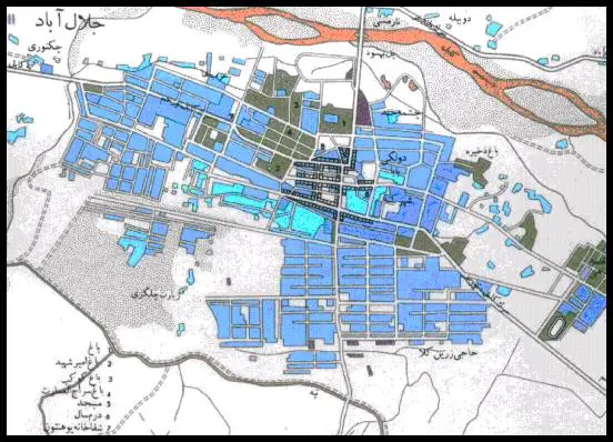
Jalalabad. Jalalabad is the largest urban center in eastern
Afghanistan between Kabul (125 kilometers [78 miles] to the west) and the
Pakistan border at the Khyber Pass (75 kilometers [47 miles] to the east). The
city has been an important commercial, telecommunications, and cultural center,
and has a population of 154,200 (U.S. Census Bureau, 2001). The city dominates
the entrances to the Laghman and Kunar valleys and is a leading trading center
with India and Pakistan. Oranges, rice, and sugarcane grow in the fertile
surrounding area, and the city has cane processing and sugar refining as well as
papermaking industries.
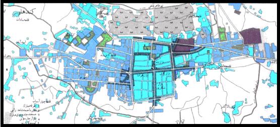
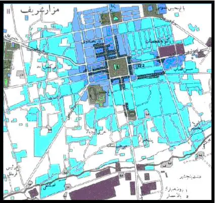
Mazar-e Sharif. Mazar-e Sharif, the provincial capital of the Balkh
Province, is situated on the main route between Kabul and the Termiz,
Uzbekistan. Historically, its importance was twofold: it was 70 kilometers (43
miles) south of the Soviet Union, and it was a center for Afghanistan’s
fledgling oil industry. Its population is estimated at 232,800 (U.S. Census
Bureau, 2001).
Herat. Herat is centered in western Afghanistan on the flat river
plains a few kilometers north of the Harirud River. The Iran border is
approximately 120 kilometers (75 miles) to the west, Turkmenistan 110 kilometers
(68 miles) to the north, and Kabul is approximately 650 kilometers (400 miles)
to the east. Elevations within the city range from roughly 920 meters (3,018
feet) ASL in the south to 960 meters (3,150 feet) ASL in the north. Mountains
ranging in height from 1,800 meters to 3,300 meters (about 6,000 to 11,000 feet)
surround the city. Earthquakes and tremors are common occurrences. Herat
experiences a hot, north-northwesterly wind from May to September. This wind
blows constantly, but is particularly strong in the afternoon; wind velocity is
typically around 50 miles per hour (43.5 knots), with gusts up to 80 miles per
hour (69.5 knots).
SECTION XI: CULTURAL FACTORS
Even though ethnicity has only recently surfaced as a central issue, ethnic
divisions and internal colonization have existed in Afghanistan for the last 250
years. Since Ahmad Shah Durani founded the Afghan state in 1747, various
Pashtun-dominated regimes (monarchic, republican, communist, Islamist) have used
the powers and institutions of the central government to colonize the
non-Pashtun ethnolinguistic areas. To this end, Pashtun regimes tried various
Pashtunization measures (political, educational, linguistic, economic,
demographic, social, and economic) to suppress and weaken other ethnic
communities and their hold on territories and to ensure Pashtun supremacy and
domination.
Pashtun domination ended with the Soviet invasion of Afghanistan in 1979,
when Babrak Karmal, leader of the Parcham faction of the People's Democratic
Party of Afghanistan (PDPA), became president. The Parcham, unlike the Khalq
faction, was composed mostly of non-Pashtuns. The Tajiks, Hazaras, Uzbeks, and
other minority ethnic groups were allowed equal participation in politics,
education, economics, and other aspects of life in the Afghan communist
government. Under its so-called nationalities policy, minority languages and
dialects – such as Hazaragi, Uzbeki, Baluchi, Pashai, and others – began to
flourish, and Tajiks, Hazaras, Uzbeks, and other minority ethnic groups were
appointed to positions in the foreign ministry, including diplomatic posts
abroad, as well as in the Ministries of Defense and Interior.
These opportunities changed the balance of power for the minority ethnic
groups inside Afghanistan. By the time the Soviet forces withdrew in 1989, there
were many more Tajiks, Hazaras, Uzbeks, and other minorities than ever before
serving as pilots, engineers, doctors, ambassadors, military generals,
ministers, central committee members, governors, university professors, and so
on. One Hazara, Sultan Ali Keshtmand, even became prime minister, something
unthinkable during the Pashtun-dominated regimes in the past.
The situation among the Afghan refugees in Pakistan during the Soviet
occupation was different, however. In Pakistan, the Pashtuns dominated the
Afghan refugee political parties. Of the seven political groups in Peshawar,
Pakistan, only one – the Islamic Society (Jamiyat-e Islami) headed by Burhanudin
Rabani – was non-Pashtun; the others were all Pashtuns, either linguistically or
genealogically. This meant that most of the cash and weapons provided by the
United States, Saudi Arabia, and others went to the Pashtuns, as well as the
lucrative jobs related to the humanitarian assistance agencies and other
organizations helping the Afghan refugees.
When the Islamic groups came to power in 1992, the ex-communists in the
government joined the mujahidin according to their ethnic affiliation. The
Pashtuns sided with Gulabudin Hikmatyar's Islamic Party (Hizb-e Islami) – a
Pashtun party – while the non-Pashtuns supported Ahmad Shah Massoud, a Tajik and
Rabani's military commander, and his Supervisory Council (Shoray-e
Nezar)/Islamic Society (Jamiyat-e Islami). This division established the
parameters for the beginning of a civil war based on ethnic divisions.
In 1994 when Gulabudin Hikmatyar, a Pashtun and the creator of Pakistan's ISI
(Interservices Intelligence) failed to rally the Pashtuns and to seize Kabul
from Tajik Massoud, the Taliban, a Pashtun-dominated Islamic militia said to
have been created and supported by Pakistan and some Arab countries – especially
Saudi Arabia and the United Arab Emirates – took over the fight for Pashtun
domination. Pakistan, with its own significant Pashtun minority, has been
exploiting the ethnic and sectarian conflict for its own objectives. Iran and
Uzbekistan, and to some extent Tajikistan, feared the Islamic fundamentalism of
the Taliban and assisted the non-Pashtuns with whom they have an ethnolinguistic
and cultural affinity. This has intensified the ethnic conflict in Afghanistan.
Since 1997 some ethnic cleansing has also taken place in which the Hazaras
and the Pashtuns have reportedly massacred thousands of each other's people in
Mazar-e-Sharif, in Bamyan, and in other regions. Also, the Taliban have
reportedly evicted Tajiks from the Shomaly Valley north of Kabul and sent them
to Kandahar along with some Hazaras and other members of minority ethnic groups.
There are reports that the Taliban have brought Pashtuns to settle on the land
and in the houses taken from dislocated Tajiks, Hazaras, and others.
SECTION XII: NATIONISM AND NATIONALISM
The ethnic issue poses problems of terminology. The words “nation” (mellat)
and “nationality” (melliyat) with their European origin do not have the same
meaning in the Afghan context or among the various ethnic groups. In the West,
“nation” implies citizenship and refers to a “community of people composed of
one or more nationalities and possessing a more or less defined territory and
government,” it has a completely different meaning to the Afghan ethnic groups.
To the Pashtuns, “nation” subsumes a combination of notions, encompassing
geography, ancestry, language, religion, culture, and nation-state. In the
Pashtuns' view, the Afghan nation refers to those people who originally settled
near the Suleiman Range and spread to what is now modern Afghanistan and
Pakistan. Pashtun nationalists say “Afghan” also refers to the descendants of
the Prophet Ibrahim. Furthermore, they insist the Afghan nation belongs to the
people who have been speaking Pashto as a native language for many generations.
To the Pashtun nationalists, the Afghan nation also refers to the “real”
citizens of Afghanistan – a “typical” or “true” Afghan is a conservative,
orthodox Sunni Muslim. Most importantly, to the Pashtun nationalists, real
Afghans are those who have Pashtun tribal customs and traditions. This may
explain why their well-known nationalist political party and their newspaper are
both named “Afghan Mellat” and “Afghan Nation” (that is, Pashtun Nation).
According to nationalist Pashtuns, an individual is considered an Afghan if he
possesses “all” of the above qualifications, not just one or two. For example,
speaking Pashto as a native language or being a Sunni Muslim alone does not make
one an Afghan citizen, at least in the eyes of the nationalist Pashtuns.
The non-Pashtuns have their own interpretation of these terms. Unlike the
Pashtuns, they do not identify themselves as a nation (mellat) because they do
not feel they were treated as “real” citizens with equal rights by the
Pashtun-dominated regimes. Instead, they refer to themselves as nationalities
(melliyat) or ethnic groups (qawm). While the word “nation” specifically refers
to territorial boundaries, melliyat identifies a specific group on the basis of
such cultural factors as language, sect, customs, mores, ideals, cultural
habits, and traditions. In the Afghan context, melliyat and qaumiyat are
synonymous and can be translated as “ethnicity,” although melliyat is more
general than qaumiyat because a melliyat can consist of more than one qawm. To
non-Pashtuns, only the Pashtuns are referred to as a nation because they have
had the nation-state and the political system under their control, without
giving equal rights to the minorities. In fact, the Tajiks, Uzbeks, Hazaras, and
other minority groups refer to the Pashtuns as “Afghans.” “Afghanistan”
literally means “the land of the Afghans” (that is, Pashtuns). That is why when
asked about their identity, these non-Pashtun ethnic groups call themselves
“Hazaras,” “Tajiks,” “Uzbeks,” and so on instead of “Afghans.”
In Afghanistan one's loyalty is still first and foremost to the family,
qawm/tribe, sect, and even geography (place of birth) instead of to the “Afghan
nation” as a whole. In the words of one non-Pashtun diplomat, “It is hard to
ascribe any other term [Afghanistan] to [the territory called Afghanistan]
including country, nation, government, and national identity . . . Ethnic,
familial blood determines everything.” The precise ranking of loyalties in a
given situation depends on what is at issue. As a general rule, religion/sect or
ideology supersedes ethnolinguistic group or tribe/qawm. During the Soviet
occupation, all the Afghan ethnic groups united against the communists in a holy
war. After the defeat of the communists, ethnicity became the issue. For
example, when the mujahidin took Bagram military airport north of Kabul in 1992,
the Pashtun communists joined the forces of Gulabudin Hikmatyar, a Pashtun, and
the Tajik communists joined Ahmad Shah Massoud.
SECTION XIII: DANGEROUS PLANTS AND ANIMALS
Afghanistan has a number of large mammal species that could pose a threat to
U.S. personnel. Brown bears, Siberian tigers, and several species of leopards
inhabit the mountains and foothills. Wolves, striped hyena, jackal, wild pigs
and wild dogs are widespread. In addition, soldiers should expect to encounter
numerous venomous reptiles, insects, and plants.
|