|
CHAPTER IV: Somalia Country Study
SECTION I: GEOGRAPHY
A. Location and Description
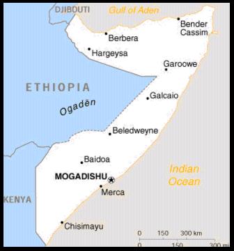
Somalia is located in the northeastern section of Africa known as the Horn of
Africa. It occupies a land area of approximately 637,600 square kilometers
(185,655 square nautical miles), which is slightly smaller than Texas. The
country consists of the area comprising the former colonies of Italian and
British Somaliland. The south and east coast were formerly under Italian
administration, and the area along the Gulf of Aden coastline was the British
colony. The country is shaped like the figure “7”, or an open jackknife.
The northern and eastern boundaries of Somalia are the Gulf of Aden and the
Indian Ocean respectively. The total coastline is approximately 2,500 kilometers
(1,350 nautical miles) with 1,000 kilometers (539 nautical miles) bordering the
Gulf of Aden and 1,500 kilometers (809 nautical miles) bordering the Indian
Ocean.
The border with Djibouti is 58 kilometers (31 nautical miles) long. It begins
along the Gulf of Aden and runs on a straight line southwesterly to the
Djibouti-Ethiopia-Somalia tri-point located at Madaha Jalelo, a hill.
The border with Ethiopia is approximately 1,600 kilometers (863 nautical
miles) long. Beginning at Madaha Jalelo, the border runs in a southeasterly
direction.
The border between Somalia and Kenya is 682 kilometers (368 nautical miles)
long. At the Kenya Ethiopia-Somalia tri-point, the boundary runs southwest in
straight-line segments to the town of El Wak. It then runs north to south and
then southeasterly to the Indian Ocean.
B. Weather and Climate
As a result of Somalia’s geographical position, the climate of southern
Somalia is equatorial, while the north is generally described as subtropical.
The country is uniformly hot, with the most oppressive heat occurring along the
northern coast during the summer. Rainfall varies greatly in both total amount
and reliability throughout the country. Humidity is high along the coast and in
the south, and somewhat lower in the northern highlands.
During the winter season, late December through February, high-pressure cells
over Arabia result in northeast winds over much of Somalia. Occasional cyclonic
storms may arise over the Red Sea and Gulf of Aden during this period, blown to
the southwest by the winds generated by these high-pressure systems.
In the spring, starting in mid-March, most of southern Somalia is under the
effect of the inter-tropical convergence zone (ITCZ). Winds are generally
southerly or southeasterly during this period. Northern Somalia and the Gulf of
Aden generally have northwesterly winds during this time.
April is the onset of the southwest monsoon over southern Somalia. Low
pressures over India and Pakistan result in moisture laden, southeasterly winds
moving onshore over the coastal regions of Somalia. The ITCZ proceeds northward
over Somalia during this period. By June, the entire country is under the effect
of the southwest monsoon.
Starting in September the northern coastline comes under the influence of
dry, stable air resulting from high-pressure systems over the Middle East and
Asia. During this period southern and central Somalia are under the effect of
the southward movement of the ITCZ, resulting in unstable weather.
1. Precipitation: There is a marked variability in the amount and
reliability of precipitation throughout the country. Precipitation increases
toward the south, with a large area of the south receiving in excess of 58
centimeters (23 inches) in most years. The north coast generally receives less
than 10 centimeters (four inches) per year. The interior plateau receives 25 to
48 centimeters (10 to 19 inches) per year. The southwest monsoon, beginning in
April, is responsible for most of the precipitation.
2. Temperature: Temperatures in Somalia are relatively uniform
throughout the year because of the equatorial location and lack of significant
mountain ranges. The average annual temperature for most coastal locations is
80oF, although the northern coastal region has temperatures
approaching 113-115�F during June and July. Winter temperatures in this region
may reach as low as 54-57�F.
C. Topography
Most of Somalia is desert or semi-desert; drought is a year-round threat.
Approximately 60 percent of Somalia is savannah woodlands, which is used as
rangeland and as the primary local source of fuel. Only about 13 percent of the
land can be cultivated, and much of that is not farmed on a regular basis.
Cultivation of arable land occurs primarily in southern Somalia. Somalia has
rich fishing grounds and the longest coastline in Africa.
Mountains are limited to the northern part of the country, while the entire
southern and eastern sections consist of a narrow coastal plain and a large
interior plateau. Extensive undulating plains, which are interrupted
occasionally by areas of dissected terrain and isolated hills, characterize much
of Somalia. The country can be divided into four distinct geographic regions:
the Guban, a plain along the northwestern coastal area extending north
into Djibouti; the Northern Somali Mountain area in northern Somalia; the
Somali Plateau, subdivided into a northern and southern section, located
along the Ethiopian border; and the Coastal Plains along the Indian Ocean
shore.
1. The Guban
The low-lying country from the western boundary with Djibouti, and
extending eastward along the Gulf of Aden, is locally referred to the
Guban. The extreme northwest section of the Guban is covered with barren
lava fields originating in Djibouti, with additional lava flows immediately west
of Berbera. The lava plain ends in a series of low hills and merges into an
alluvial plain. The plain is up to 80 kilometers (43 nautical miles) wide from
north to south near Seylac and extends eastward to beyond the town of Berbera.
The plain becomes narrower as it extends in an eastward direction, at the town
of Bullaxaar, subsequently to widen again around Berbera. This plain rises
gently up to the piedmont area of the Northern Somali Mountain region.
2. Northern Mountains
The highest elevations in Somalia are found in the Northern Somali
Mountain region located along the Gulf of Aden, stretching from the
Somali-Ethiopian border in the west to the coast of the Arabian Sea in the east.
In places, the mountains are in close proximity to the shore along the Gulf of
Aden. The average elevation for this mountain range is about 2,000 meters (6,561
feet). At its highest point, Shimber Berris, located about 19 kilometers (10
nautical miles) northwest of Erigavo, is 2,410 meters (7,906 feet). A fault zone
delineates the northern front of the mountains. The boundary of the uplifted
area is separated from the Gulf of Aden by a coastal plain varying in width from
60 kilometers (32 nautical miles) in the west to less than 1 kilometer (.5
nautical miles) in the east.
Dry watercourses, locally called tugs, dissect the mountainous region.
These are dry for most of the year, but usually contain water for several hours
after a rain. Many of the tugs form deep gorges and gullies. The gorges’
alignment is predominantly north to south. The tugs provide the water and the
fluvial deposits for the geographic region lying south of the mountain belt, the
Northern Somali Plateau.
3. The Somali Plateau (Subdivided)
Northern Somali Plateau. The plateau, located in northern
Somalia just to the south of the Northern Somali Mountain region, consists
primarily of alluvial plains. The Somali refer to this region as the Haud. The
Haud plains are wide and open, nearly level, and slope gently to the south. The
elevation changes over a distance of about 300 kilometers (161 nautical miles)
from an average of 1,200 meters (3937 feet) near the northern mountains to about
700 meters (2297 feet) at the boundary with Ethiopia. Curious features of this
landscape are the anthills and termite mounds. Termite mounds can reach a height
of 8 meters and stand as hard, irregular pillars. Anthills are found only in
areas where there is limestone with a thin covering of alluvium.
Southern Somali Plateau. The Southern Somali Plateau region
is located between the Webi Shabeelle and the Webi Jubba; “Webi” meaning
seasonally flowing river in Somali. The plateau is comprised of gently
undulating limestone surfaces with occasional, isolated low hills. The plateau
extends eastward from the Ethiopian border. Where the plateau reaches the
coastal plains in the east, crystalline rocks replace the limestone surface. The
change from plateau to coastal plain is almost unnoticeable except north of Webi
Shabeelle, where there is a short steep escarpment.
4. Coastal Plain
The Coastal Plain area stretches from the southern tip of Somalia along
the Indian Ocean as far north as Hurdiyo. The plains become progressively
narrower as the Northern Somali Plateau reaches closer to the coast in the
northern areas. North of Hurdiyo the plateau reaches the coast.
The Coastal Plain is a low-lying area with elevations below 300 meters
(984 feet). The two major rivers cited above, the Webi Shabeelle and Webi Jubba,
traverse the plain. These rivers are flanked by natural levees. On the plain,
flanking the rivers, are numerous depressions called descecks, which fill with
water during the rainy season and during floods.
The Coastal Plain region, on which Mogadishu lies, is the largest
geographic region in Somalia. The plain is “emergent,” gradually uplifted along
most points along the Indian Ocean. As a result, beaches along the coast are
often short and steep with irregular formations near shores and backed by cliffs
of coral or limestone on the backshore. The coastline is often terraced, and
unstable “blowout” dunes up to 50 meters (164 feet) high are scattered along the
entire length of the coast from Kenya northward almost to the Gulf of Aden. As
one moves inland from the coast, the terrain gradually ascends in a series of
undulating stabilized dunes and sandy plains, interrupted only by the shallow
but wide flood plain of the Webi Shabeelle.
D. Vegetation
Climate, elevation, man, and soil affect the vegetation in Somalia. Climate
has the most pronounced effect, with annual rainfall being the dominant climatic
factor. More specifically, due to the importance of precipitation, this dictates
the types of vegetation capable of surviving the harsh environment common
throughout the country. Elevation is also a controlling factor in determining
the type of vegetation found in an area due to the various temperature ranges,
particularly colder temperatures, which are common to mountainous regions. Cold
temperatures, coupled with a paucity of water, create the harshest conditions
for vegetation. Besides climate and elevation, human activity also contributes
to controlling or modifying the vegetation regimen in the region. Over one-half
of the population is nomadic animal herders, and their overgrazing herds of
goats, sheep, camels, and cattle have caused widespread change in vegetation
throughout the country. This has led to the increasing problem of
decertification, especially during periods of drought of recent years. Aside
from human activity, the soil will affect the occurrence of a particular type of
vegetation.
The coastal areas in Somalia are strongly affected by the intrusion of salt
from the ocean. Subsurface movement of ocean water and its subsequent rising to
the surface, coupled with evaporation, causes the deposition of salts on the
surface. The intrusion of saltwater is aided through the extensive use of ground
water, little precipitation, and destruction of ground cover due to overgrazing.
The salt flats are entirely void of vegetation.
Irrigation projects have also modified vegetation in Somalia. There are large
irrigation projects along the Webi Jubba and Webi Shabeelle. Agriculture
products, such as bananas and papayas, are grown in the region. Rice is also
cultivated in the vicinity of the Webi Shabeelle.
1. Natural vegetation types in the four geographic regions:
The Guban area has broadleaf evergreen vegetation. This region is
characterized by dry climatic conditions. The vegetation includes acacia trees,
about three meters (10 feet) high, scattered throughout the region, with thorny
acacia bushes and other shrubs. Grasses grow sporadically in the region. Tall
tamarisk trees grow along dry river courses as well as in large tug beds. The
smaller tug beds only support grasses and brush along their banks. The sand
dunes in the Guban area support bunch grasses. Low sand dunes support grasses or
salt bushes, but not both.
The northern mountain vegetation is mainly controlled by elevation and
secondarily by precipitation and soils. The northern mountain region has three
distinct regimes depending on altitude: open woodland, shrub evergreen, and
juniper. The open woodland consists of acacia trees that range in height up to
eight meters. Interspersed with these trees are low shrubs. The acacia trees are
found up to 1,500 meters (4,921 feet) in elevation. Above 1,500 meters (4,921
feet), vegetation changes to needle leaf evergreen shrubs ranging from one meter
(3 feet) to four meters (13 feet) in height. The acacia open forest that stood
in large segments of northern Somalia has died off and now remains as a dead
forest, giving the area a bleak appearance. The death of these trees is due to
drought and overgrazing.
The shrub evergreen vegetation gives way to juniper at the highest
elevations in the mountain areas. The juniper trees grow close together. The
scrubs form locally dense thickets in scattered pockets throughout the area.
Trees are generally more than eight meters (26 feet) tall, but local inhabitants
cut the forest for poles. This area has also been heavily grazed.
The Northern Somali Plateau is characterized by open spaced bush-type
vegetation. Its mixed deciduous vegetation consists of acacia and commiphora.
This region has experienced overgrazing to such a degree that large areas are
devoid of trees. The result is that significant areas are devoid of vegetation.
Shrub vegetation that remains in this area varies in height from one meter (3
feet) to five meters (16 feet). Occasionally a tree may reach a height of 10
meters (32 feet).
Throughout the northern plateau area, there are places where pools of
water form after rain. These pools may vary from a few meters across to several
hundred meters. These pools generally last for a day or two. The soil in these
pools is usually gray, sandy clay, which will crack when dried. The small
temporary pools support grass clumps from one meter (3 feet) to two meters (2
feet) in height. The larger pools are known locally as “ballehs.” These may
retain water throughout the year, although the water level drops. The dry balleh
floor does not support any vegetation. Along the edges, however, bunch grasses
and scattered acacia trees grow.
The vegetation of the Southern Somali Plateau is predominantly bunch
grasses with scattered acacia trees in areas that have a moisture source, such
as watercourses. Very little agriculture is practiced in the area due to sparse
precipitation.
The Coastal Plains are divided into two separate zones. Short grasses
interspersed with isolated trees and brush vegetation characterize the northern
section, located north of the Webi Shabeelle. Along the tugs some tree growth
occurs. The grassland in this area is used for grazing. In the areas along the
Webi Shabeelle and Webi Jubba, dense vegetation is found along the river
channel. South of the river, typical savannah vegetation takes over,
characterized by grass-covered areas with trees growing along the river channels
and near sources of water.
2. Cultivated Cropland
Cultivated cropland is confined to two areas: the hills and high plains
north and west of Hargeysa and the land along and between the Webi Shabeelle and
the Webi Jubba. Agriculture along the two rivers is based on controlled
irrigation or field inundation during high water periods. Primary crops are
bananas, sorghum, and millet. Bananas are a major source of export income for
Somalia. Other crops consist of corn, wetland rice, beans, and sesame. Near
Hargeysa and on the land between the two rivers, agriculture consists of small
plots of crops sustained by natural rainfall. Other crops grown include
groundnuts, cowpeas, mung beans, and corn.
E. Drainage
Somalia has only two perennial rivers, the Webi Shabeelle and Webi Jubba. The
rivers originate in Ethiopia and flow southward into southern Somalia. The Webi
Jubba is more than 150 meters (492 feet) wide and unfordable during high water
levels that occur from May through June and September through November. The
river is fordable in places during the other months when the low water period
prevails. In the driest years, the Webi Jubba is fordable throughout its course
and dries up for short periods south of Baardheere. The Webi Shabeelle flows
south from Ethiopia to Balcad, about 30 kilometers (16 nautical miles) north of
Mogadishu. The banks of the Webi Shabeelle at Beled Weyne vary in height from
two to six meters (6 to 19 feet) depending on the water level of the river. The
terrain directly adjacent to the river is relatively flat, although the terrain
rises rapidly to the north. The Webi Shabeelle runs through a large swampy
region near the coast through numerous natural channels and diversions for 360
kilometers (194 nautical miles) to a confluence with the Webi Jubba at Jilib.
During the high water season, this portion of the Webi Shabeelle floods
extensively. The river is not perennial in this area, but dries up for about two
months during the dry season. The Webi Shabeelle is unfordable in much of its
course from the Ethiopian border to Balcad during the high water periods.
Except for the Webi Shabeelle and the Webi Jubba, all streams are
intermittent. Watercourses are widely separated and usually contain water for
only a few hours following a rainstorm. Water levels rise rapidly and
flashfloods occur. Streams are most likely to have water during April, May,
October, and November. Stream banks are low and sandy or clay on the plains and
deeply entrenched between high, steep rocky banks in the hills. Bottoms
generally consist of boulders in the hills and sand and sandy gravel elsewhere.
From the Webi Shabeelle north to Garoowe, drainage is disorganized and rainwater
sinks into the ground after flowing a short distance. Few watercourses reach the
sea.
In the Northern Somali Mountains and the Guban, streams flow northward or
into the Gulf of Aden. Stream channels and waterholes are usually dry and carry
water only for periods of a few hours to a week after heavy rains during July
and August. When streams are flowing, they are fairly deep and swift in their
upper courses and broad, shallow quagmires in their lower courses. Stream banks
are usually high, steep, and rocky in upper courses and generally low, ill
defined, and sandy in lower courses. Bottoms consist primarily of boulders,
cobbles, and gravel in the upper courses and sand and sandy gravel in lower
courses.
F. Cross-Country Movement (CCM)
Suitability for cross-country movement in Somalia is heavily dependent on
weather. During the dry conditions that prevail most of the year, cross-country
movement conditions are good in nearly all of Somalia. The only severe
restrictions that may be encountered are the steeper slopes of the mountains in
the north and the escarpments facing much of the East Coast. During wet periods,
movement of personnel on foot would be limited for periods of hours to days by
flowing streams. However, only the Webi Jubba and the Webi Shabeelle pose
long-term obstacles. Throughout the year personnel on foot must take great care,
especially in low light conditions, to avoid thorn bushes. Thorns up to eight
centimeters (3 inches) long can cause serious injury, even penetrating the sole
of a combat boot. Dense thickets of thorny shrubs and cactus may obstruct
movement locally. In populated areas, closely plated hedges of thorn bushes
marking borders of fields and fencing livestock would hamper travel. During dry
periods in most locations, wheeled and tracked vehicles can cross most of the
country, but they would be impeded significantly by rocky ground and sand dune
fields in the Guban, by moderate to steep slopes and stream channels in the
hills and mountains, and by steeply cut banks and sandy beds of intermittent
streams. Under wet conditions, wheeled and tracked vehicles would be slowed or
obstructed in most areas.
SECTION II: POPULATION AND DEMOGRAPHY
A. Demographics
All figures are 2001 estimates unless otherwise noted.
Population: 7,488,773*
Density: 11.9 persons per square kilometer of land
Birth rate: 47.23 births/1,000 population
Death rate: 18.35 deaths/1,000 population
Net migration rate: 5.96 migrant(s)/1,000 population
Population growth rate: 3.48%
Population doubling time: 233 years
Total fertility rate: 7.11 children born per woman
Infant mortality rate: 123.97 deaths/1,000 live births
Life expectancy: males 44.99, females 48.25, total 46.6
Urban/rural population distribution: 28% urban/72% rural
Sex ratio: 1.01 male(s)/female
Age structure: 0-14 years: 44.54% (male 1,670,320; female 1,665,329)
15-64 years: 52.69% (male 1,993,750; female 1,952,437)
65 years and over: 2.77% (male 91,511; female 115,426)
Population projection, 2010: 9,922,031
Number of military-aged males (15-49): 1,825,302 (1,011,398 fit for
service)
* A census has not been taken since 1975. Population estimates vary widely,
ranging between 7-10 million.
B. Area and Population
Somalia occupies 637,657 square kilometers, a size slightly smaller than
Texas.
| Region |
Population, 1998* |
| Awdal |
212,250 |
| Bakol |
212,510 |
| Banadir |
950,310 |
| Bari |
171,090 |
| Bay |
621,616 |
| Galgudud |
370,997 |
| Gedo |
280,945 |
| Hiran |
258,071 |
| Lower Juba |
331,715 |
| Lower Shabeelle |
809,446 |
| Middle Juba |
389,730 |
| Middle Shabeelle |
394,392 |
| Mudug |
263,340 |
| Nugal |
105,120 |
| Sahal |
55,110 |
| Sool |
190,455 |
| Togdheer |
270,606 |
| Woqooyi Galbeed |
354,225 |
* Source: UN Children's Fund. Does not include nomads or refugees.
Population of Principal Places, 2001*
| Mogadishu |
1,000,000 |
| Hargeisa |
111,000 |
| Kismet |
50,000 |
| Berbera |
35,000 |
| Borama |
30,000 |
* Population figures better illustrate relative sizes rather than actual
population numbers. Populations of Somali cities change frequently depending on
political and climatic conditions.
C. Ethnic Composition. Eighty-five percent of the people of Somalia
are Somalis, who are divided into numerous clans that provide the basis for
group identity. Bantus predominate in a few coastal areas in the south. Nearly
all the Arabs and all of the Italians that used to live in Somalia have
departed.
D. Language. The vast majority of Somalis speak Somali or one of its
regional derivatives. Approximately 50,000 persons speak Bantu languages and
only on the coasts near the Kenyan border. Despite the fact that Arabic is a
national language, few people actually speak the language at any level of
society.
E. Religion. Somalia is almost universally Sunni Moslem. In 1997 there
were an estimated 200 Roman Catholics in the country.
F. Education. There are few functioning educational institutions due
to the recent hostilities. No reliable data are available.
G. Labor and Economy. In 1997, the labor force was estimated at
4,416,000. Of these, 3,201,000 (72.5%) were employed in the agricultural sector,
often at the subsistence level. Those not involved in agriculture are either
unemployed or work in the informal sector.
1. The Economy
In the prolonged absence of a central government, Somalia’s war-torn
economy as a whole has experienced long-term recession and deterioration. During
the 1990s, the gross domestic product (GDP) shrank in inflation-adjusted terms
by 75 percent. For 2000, the estimated GDP amounted to $1.7 billion, or only
$170 per capita (among the lowest in the world). Of 170 countries, Somalia ranks
near the bottom on the United Nations Human Development Index – a composite
measure of life expectancy, adult literacy, and real GDP per capita.
Civil war, drought, and livestock disease have decimated Somalia’s
economic sectors, which remain fragmented by the three main opposing regional
administrations of the country (the Transitional National Government in the
south, Puntland in the northeast, and the Somaliland Republic in the northwest).
a. Agriculture. Cattle husbandry is the mainstay of economic
activity and provides the primary source of food and foreign exchange earnings.
In 2000, countrywide stock-rearing accounted for about 40 percent of GDP and 65
percent of export earnings. This sector was hurt when Saudi Arabia and other
Gulf states imposed a ban on the import of Somali livestock following an
outbreak of Rift Valley fever. Also, drought is causing hardship in all parts of
Somalia.
b. Manufacturing. Some private food-processing and
boat-building businesses in a few of the larger settlements are now all that
remain of the small manufacturing sector.
c. Mining. Somalia’s mineral resources have undergone little
exploration. Commercially exploitable deposits of gold, silver, tungsten,
manganese, titanium, chromium, and nickel remain undeveloped. A cement factory
and a gypsum plant at Berbera, which used local non-metallic mineral deposits
before the civil war, are no longer operating.
d. Services. Somalia’s retail trade, hit hard by the civil
war, is supplied largely by the informal sector. Mogadishu’s main market,
Bakara, offers a wide range of consumer goods and weaponry.
e. Trade. Officially recorded foreign trade, which has
suffered greatly because of the civil war, virtually ceased in September 2000
when the livestock ban caused a loss of sales, export levies, and port revenue,
severely affecting the economies of Somaliland and Puntland.
f. Finance. Primary sources of “government” revenue are import
duties, overseas remittances, and informal duties and taxes.
-
- Import Duties: Duties levied at the port of Berbera generate a large
share of government revenue in Somaliland.
-
- Overseas remittances: Private transfers from the Somali diaspora are
another important source of Somaliland’s income; estimated remittances amount to
as much as $500 million a year.
-
- Informal Duties and Taxes: In many areas, duties on “qat” (a mild
narcotic) and taxes collected by clan factions represent significant sources of
income. Most of these proceeds are paid to conventional government employees in
Somaliland and to clan faction militias in the rest of the
country.
2. Defense Spending. Defense spending by the ruling factions is
probably minor because of limited means to generate revenue. In the year 2000,
estimated spending for military-related forces of the Somaliland Republic and
clan militias totaled $15 million, or less than one percent of the GDP.
SECTION III: CLANS AND FACTIONS
A. Background
Approximately 94 percent of Somalia’s eight million inhabitants are members
of six major clan families. Centralized rule in Somalia ceased with the fall of
the Siad Barre regime in 1991 and was replaced by several competing regional
administrative areas and local warlord fiefdoms supported by the major clans and
their subgroups. Any efforts to target Al-Ittihad Al-Islami (AIAI) could have
the undesired effect of alienating the clans, particularly in the event that
unintended collateral damage results. Since AIAI personnel also belong to a
clan, it would be very difficult to attack them without appearing to attack the
clan to which they belong. Doing so could spur wider conflict in Somalia and
undermine the modicum of order it has achieved since 1995.
B. Somalia’s Clan Structure
Somalis are divided into clan families. The six major clan families are the
Darod, Dir, Hawiya, and Ishaak, which account for about 74 percent of the
population, and the Digil and Rahanwein, which make up another 20 percent. There
are also many sub-clans. The first four clan families are generally pastoral
nomads. They consider themselves superior to the Digil and Rahanwein who
practice farming.
The main clan families are interspersed throughout the country. They are not
located in single discrete regions. The Darod inhabit a broad swath extending
from the Ethiopian border in central Somalia to the northeast, but they are also
found in far southern Somalia near the Kenyan border. The Dir occupy the
northwest. The Ishaak are found between the Dir and the Darod in the far north.
The Hawiya are mostly located in south-central Somalia in a large area from the
seacoast to the Ethiopian border. The Rahanwein inhabit the south-central part
of the country near the Ethiopian border, while the Digil are found in small
enclaves in the southeastern part of the country.
All clan families and sub-clans maintain armed militias and look to their
traditional home territories as a power base, manpower pool, and place of
refuge. In most cases, an armed faction’s area of influence and operations
corresponds to its supporting clan’s home territory. Supplies can be looted or
furnished by allies, however, offsetting personnel losses is more problematic as
there is a limited manpower pool. Warlords can depend only on soldiers belonging
to their sub-clans to fill manpower levies. Havens provided by clan holdings are
not limited to Somalia proper, but can extend into neighboring areas inside
Ethiopia and Kenya that are populated by ethnic Somalis.
Normally, clan affiliation is the most important single factor in determining
factional alignment, but it is not always preeminent. The northern third of the
country includes the self-proclaimed administrations of Somaliland in the
northwest and Puntland in the northeast. Clans in these regions have little
direct impact on what transpires in the south. The south, central, and
northeastern parts of Somalia is where the majority of clan conflict and famine
occurs.
C. Clan Interrelationships
The warlords of the various factions make and break alliances with other
warlords based on clan relations, the demand for resources, the need to
counterbalance the strength of a rival, revenge, and the advancement of their
own fortunes. These factors, in some form, have been present in typical
interfactional alliances and disputes.
Yet according to academic experts, most armed conflict in Somalia since 1995
has been within rather than between major clan families. Relations between clans
have tended to be extremely fractured. This is qualitatively different from the
clan conflict of the 1991-92 period when, for example, the Darod and Hawiya clan
families were arrayed against each other following the ouster of Siad Barre and
competed for the control of large territorial areas. In recent years, Somali
warlords have been focused on localized economic profits more than they have on
pursuing national political ascendancy based on military power. Intra-clan
fighting has been more common than inter-clan conflict. Clan warlords receive
support from external sources. Such support encourages them to believe that they
are better off controlling a regional area than aiming to control a Somali
state.
SECTION IV: MEDICAL THREATS
A. Infectious Disease Risk Assessment
The Armed Forces Medical Intelligence Center (AFMIC) assesses Somalia as a
HIGHEST-RISK country, with an overall disease risk among the worst in the world.
Without force health protection measures, mission effectiveness will be
seriously jeopardized. The main force health protection emphasis should be on
these diseases, which have the greatest likelihood to degrade operations by
affecting a large percentage of personnel, or by causing severe illness in a
smaller percentage. Greatest-risk diseases are grouped into transmission
categories that are prioritized in descending order of risk.
Food-borne and Water-borne Diseases: Diarrhea (bacterial, Hepatitis
A, Typhoid/paratyphoid fever Diarrhea), cholera
Vector-borne Diseases: Malaria, Dengue fever, Rift Valley fever
Sexually Transmitted Diseases: Hepatitis B
Animal-contact Diseases: Rabies
Diseases of Potential Risk: These diseases also warrant force
protection emphasis. They are assessed to have lower likelihood to degrade
operations because they generally affect smaller numbers of personnel or cause
mild symptoms. Other diseases assessed as potential risk are those likely
present at unknown levels, which under conditions favorable for transmission
could degrade operations.
B. Food-borne and Water-borne Diseases of Greatest Risk
Sanitation is extremely poor throughout the country, including major urban
areas. Local food and water sources are heavily contaminated with pathogenic
bacteria, parasites, and viruses to which most U.S. service members have little
or no natural immunity. Diarrheal diseases can be expected to temporarily
incapacitate a very high percentage of personnel within days if local food,
water, or ice is consumed. Hepatitis A, typhoid fever, and hepatitis E can cause
prolonged illness in a smaller percentage. The diseases of greatest risk are
listed first, in descending order of expected impact.
1. Diarrhea - bacterial
Risk Assessment:
- An operationally significant number (potentially over 50 percent per month)
of personnel consuming local food, water, or ice could be affected.
- Typically mild disease treated in outpatient setting; recovery in less than
72 hours.
2. Hepatitis A
Risk Assessment:
- An operationally significant number (as high as 2-10 percent per month) of
personnel consuming local food, water, or ice could be affected.
- Typical case requires convalescence over 7
days.
Transmission Comments: May also be transmitted
person-to-person under conditions of poor hygiene and sanitation.
Typical Incubation Period: 28 to 30 days (maximum range: 15 to 50
days).
Risk Period: Year-round.
Risk Distribution:
Countrywide (including urban areas).
Surveillance and Survey
Data: Most Somalis contract hepatitis A virus infection during childhood.
The seroprevalence of hepatitis A was estimated at 96 percent in 1999. A 1992
survey detected antibodies for hepatitis A virus among 90 percent of Somalians
tested.
3. Typhoid/paratyphoid fever
Risk Assessment:
- An operationally significant number (as high as 2-10 percent per month) of
personnel consuming local food, water, or ice could be affected.
- Febrile illness typically requiring 1-7 days of supportive care with
subsequent return to duty.
Typical Incubation Period: 8 to
14 days (maximum range: 3 to 30 days).
Risk Period: Year-round.
Risk Distribution: Countrywide (including urban areas); elevated
risk in populated areas with poor sanitation.
Drug Resistance:
Regionally, resistance to the standard therapeutic agent chloramphenicol has
been reported.
Surveillance and Survey Data: The carrier rate
probably is high.
4. Diarrhea, cholera
Risk Assessment:
- A small number (potentially as high as 1 percent per month) of personnel
consuming local food, water, or ice could be affected.
- Diarrheal disease of variable severity; may require 1-7 days of supportive
care.
Typical Incubation Period: 2 to 3 days (maximum range:
1 to 5 days).
Risk Period: Year-round.
Risk
Distribution: Variable; as of March 2001, districts officially reported by
the World Health Organization (WHO) as “infected” were Baidoa, Bardera, Belet
Uen, Bossaso (11-17-XXN 049-11-XXE), Bur Hakaba (02-47-XXN 044-05-XXE), Johar
(02-46-XXN 045-31-XXE), Kismaayo (00-22-XXS 042-32-XXE), Marca, and Mogadishu.
Drug Resistance: Resistance has been reported to the standard
therapeutic agents macrolides, tetracyclines, and TMP/SMX.
Surveillance and Survey Data: Between October and December 2000,
272 cases (14 deaths) were reported in Boroma, Awdal region. Vibrio cholerae 01
Ogawa were isolated.
C. Vector-borne Diseases of Greatest Risk
The climate and ecological habitat support large populations of arthropod
vectors, including mosquitoes, ticks, and sand flies. Significant disease
transmission is sustained year-round and countrywide, including urban areas.
Serious diseases may not be recognized or reported due to the lack of
surveillance and diagnostic capability.
Malaria is the major vector-borne risk in Somalia, capable of debilitating a
high percentage of personnel for up to a week or more. Dengue fever and Rift
Valley fever are also major risks in Somalia. In addition, there are a variety
of other vector-borne diseases occurring at unknown levels, which as a group
constitute a very serious risk comparable to that of malaria. Personnel exposed
to mosquitoes, ticks, and sand flies are at high risk during day or night, in
both urban and rural areas. The diseases of greatest risk are listed first, in
descending order of expected impact.
1. Malaria
Risk Assessment:
- An operationally significant number (as high as 11-50 percent per month) of
personnel exposed to mosquitoes could be affected.
- Febrile illness typically requiring 1-7 days of supportive care with
subsequent return to duty. Falciparum cases may require intensive care or
prolonged convalescence.
Transmission Comments: Relapses or
delayed clinical symptoms are common with P. vivax and P. ovale, due to dormant
parasite stages (hypnozoites) retained in the liver; delayed P. malariae
symptoms may occur due to persistent low-level parasitemia.
Agent/Subtype: P. falciparum; P. malariae; P. ovale; P. vivax.
Typical Incubation Period: 7 to 14 days (maximum range: 7 to 30
days).
Risk Period: Year-round; particularly in southern areas.
Risk is elevated during and immediately after the rainy seasons (March through
May/June and October through November), particularly in northern and central
areas.
Risk Distribution: Countrywide (including urban areas);
elevated risk occurs along most riverine habitats, especially in the south.
Vector Ecology: Principal vectors include An. gambiae and An.
arabiensis (larval habitats include temporary pools), An. funestus (larvae occur
in permanent/ semipermanent bodies of water), and An. merus (larval habitats
include brackish water in coastal areas); all four species readily enter
dwellings to feed on humans.
Drug Resistance: Falciparum malaria
strains are resistant to the standard therapeutic agent chloroquine (likely
occurs in all malarious areas; reported from the areas of Mogadishu, Balcad, and
Baardheere (02-20-XXN 042-17-XXE). Based on limited data from neighboring Kenya
and Ethiopia, resistance also may occur to other standard therapeutic agents,
including sulfadoxine/ pyrimethamine (Fansidar), mefloquine, and quinine. Vivax
malaria strains resistant to primaquine have been reported. In 1993, a
primaquine terminal prophylaxis failure rate of 16 percent occurred among a
group of US military personnel returning from the Jubba River area.
Additionally, a Belgian Army unit of 68 paracommandos in Somalia in 1993
reported relapses of 6 vivax malaria cases after prophylaxis, indicating
resistance to primaquine.
Surveillance and Survey Data: Foci of
more intense vivax transmission occur, including the Jubba River Valley (a 24
percent attack rate for vivax malaria was reported among U.S. troops at Jilib
along the Jubba River in 1993). Cyclic epidemics of P. falciparum reportedly
occur every 3 to 5 years among central and northern area nomads, who lack
sufficient exposure to maintain immunity.
Comments: Countrywide,
Plasmodium falciparum accounts for 95 percent of reported cases, followed by P.
vivax, P. malariae, and P. ovale.
2. Dengue fever
Risk Assessment:
- An operationally significant number (as high as 2-10 percent per month) of
personnel exposed to mosquitoes could be affected.
- Febrile illness typically requiring 1-7 days of supportive care with
subsequent return to duty.
Typical Incubation Period: 4 to 7
days (maximum range: 3 to 14 days).
Risk Period: Year-round.
Risk Distribution: Countrywide (including urban areas); risk
likely exists countrywide but is elevated in the south, associated with
increased vector populations.
Vector Ecology: Vectored by Aedes
aegypti mosquitoes, a peridomestic, daybiting, container-breeding species.
Surveillance and Survey Data: In 1993, dengue fever was the
primary arboviral disease confirmed among U.S. military personnel in southern
Somalia (dengue virus serotypes 2 and 3 were isolated). In 1989, a limited
survey of residents from Berbera, Woqooyi Galbeed Region, found that 59 percent
had antibodies indicative of past infection, with 3 percent having serological
evidence of recent infection. Serological results in 1987 suggested dengue 2 as
the likely cause of febrile illness outbreaks in 1985, 1986, and 1987 among
refugees in the northwest (Hargeysa vicinity).
3. Rift Valley fever
Risk Assessment:
- During irregular peaks of transmission, an operationally significant number
(potentially 2-10 percent per month).
- Potentially very severe disease sometimes requiring intensive care;
fatalities may occur; convalescence may be
prolonged.
Transmission Comments: May also be transmitted
through direct contact with infected animals.
Typical Incubation
Period: 3 to 12 days.
Risk Period: Year-round.
Risk Distribution: Countrywide (including urban areas).
Vector Ecology: May be transmitted to humans by several species
of culicine mosquitoes.
Surveillance and Survey Data: Serologic
evidence of past infection with Rift Valley fever was detected in 7 percent of
samples from residents of Berbera in 1989.
Outbreak Information:
An outbreak late in 1997 and early in 1998 in southern Somalia (Gedo, Hiiraan,
and Shabeellaha Hoose Provinces) and northeast Kenya resulted in an estimated
89,000 human cases and hundreds of human deaths. This is thought to be the
largest outbreak ever to occur in eastern Africa.
D. Sexually Transmitted Diseases of Potential Risk
This analysis focuses on exposure to commercial sex workers (CSW), a
high-risk group for sexually transmitted disease worldwide. The sub-Saharan
Africa region has the most widespread HIV/AIDS epidemic in the world, affecting
all segments of the population. Heterosexual contact is the predominant mode of
transmission. Carrier rates for hepatitis B are also high. Though the immediate
impact of these diseases on an operation is limited, the long-term health impact
on individuals is substantial. Gonorrhea, chlamydia, and other infections also
are extremely common, and may affect a high percentage of personnel who have
sexual contact. Other diseases that often are common in CSWs include chancroid,
herpes, lymphogranuloma venereum, syphilis, and venereal warts.
Hepatitis B
Risk Assessment:
- A small number (potentially as high as 1 percent per month) of personnel
having unprotected sexual contact (particularly with commercial sex workers)
could be affected.
- Typical case requires convalescence over 7 days; chronic infection with
liver damage may occur.
Typical Incubation Period: 60 to 90
days (maximum range: 45 to 180 days).
Risk Period: Year-round.
Risk Distribution: Countrywide (including urban areas).
Surveillance and Survey Data: A limited 1995 study found
hepatitis B virus carrier rates of 19.1 percent in blood donors, 5.6 percent in
hospitalized children, and 21.3 percent in hospitalized adults in Mogadishu. In
1993, surveys of Somalians found the hepatitis B virus (HBV) carrier rate to be
between 10 and 27 percent.
E. Animal-contact Diseases of Greatest Risk
Rabies
Risk Assessment:
- Infrequent or sporadic numbers of personnel with direct contact (bites or
scratches) with local animals could be affected.
- Very severe illness with near 100 percent fatality rate.
Typical Incubation Period: 21 to 56 days (maximum range: 9
to 180 days).
Risk Period: Year-round.
Risk
Distribution: Countrywide (including urban areas).
Surveillance
and Survey Data: Reports indicate that rabid dogs frequently attack humans
in market areas; several reported attacks in the market places in Mogadishu
occurred early in 2001. According to preliminary reports, more than 60 percent
of dog/fox bite victims in Shabeellaha Hoose develop rabies and die. In 1998,
more than 25 dog bite victims in Qoryoley district (near Mogadishu) developed
rabies. Stray dogs likely are the primary reservoir and the main source for
human exposure; also likely enzootic in wildlife populations, including hyenas,
jackals, and foxes.
Outbreak Information: An outbreak in
Mogadishu occurred between January and March 2001 resulting in at least 7
clinical cases; stray dog attacks on humans were reported before the outbreak.
Although only 7 clinical cases were reported, other cases likely occurred. Packs
of stray dogs have roamed free in the area since 1991 due to uncontrolled chaos.
Comments: Most rabies exposures result in death; rabies vaccine
is not routinely available.
|